

Members of the City Council and the Planning Commission tentatively agreed in a special joint meeting last night to bring logic to the City’s Comprehensive Plan, "tweaking" it by creating two new zoning designations and significantly altering where businesses can be located and what kind of residences can be constructed in locations across the city.
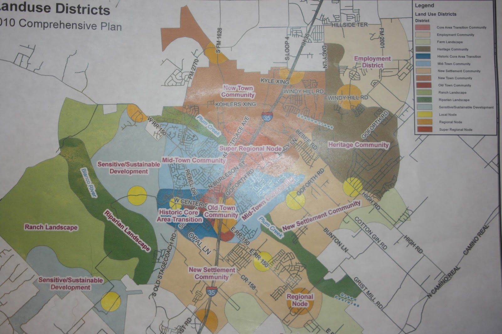
Focusing on the Comp Plan’s Landuse Districts, the two bodies also agreed to scrap the so-called "Employment District" located in far northeast Kyle, where no one plans — ever — to locate a place of employment, and to come up with an entirely new designation for the New Settlement districts located on the southern and eastern fringe of the city.
They also asked the Planning Department to prepare a three-year annexation plan to examine the possible expansion of the city’s boundaries by as much 10½ square miles, adding 5,675 to the city’s population. Most of the area planned for annexation is east of I-35.
 |
| Example of a mixed-use development |
One of the more notable omissions was the absence of designating warehouse uses anywhere in the city except as conditional uses in the New Town and Heritage districts. Warehouses provide much of the blue-collar employment opportunities that are the pistons of Kyle’s economic engine and I could easily see that underdeveloped area of Lehman Road running north from RR 150 as a designated Warehouse District.
The biggest changes were made in four landuse districts, all of which are located in or in close proximity to the downtown area: the Core Area (that pink section on the above map that straddles I-35 from just north of Center Street to Kyle Parkway), the Super Regional Node (the orange blotch just south of the Core Area); Old Town Community (the area immediately west of I-35 that includes downtown); and the Historic Core (in royal blue immediately west of the Old Town Community).
Specifically, the council and the commissioners agreed to make the following zoning changes to the Landuse Districts:
- Old Town District: Recommended zoning uses are central business district, entertainment, mixed use and office; conditional use is retail services.
- Core Area Transition: Recommended zoning uses are commercial, retail services, entertainment, office; conditional uses are multi-family residential, townhomes, condominiums.
- Historic Core Area: Recommended uses are single-family residential including the new R-1-3 zoning; conditional uses area multi-family residential, townhomes, entertainment, mixed use and retail services.
- Mid-Town (the area in light blue east and west of the Core Area): Recommended use is single-family residential; conditional uses are multi-family, commercial and entertainment.
- New Settlement: Come up with an entirely new designation for these two areas and make all zoning conditional uses.
- Sensitive/Sustainable Development: Change the name so as eliminate the idea that developments proposed in this area would be faced with extreme environmental obstacles and to allow zoning that corresponds with the development agreements already in place in this farthest southwest area.
- Local nodes (the yellow dots on the map): Add mixed use to the already-accepted residential and commercial uses as recommended; add retail services to the list of conditional uses.
- Regional Nodes (the orange circles and semi-circles): Add retail services and mixed used zoning to the already listed commercial, condo and multi-family residential uses as recommended.
- Super Regional Node: Eliminate condos and add entertainment, retail services and mixed use to the list of recommended uses; eliminate all the listed conditional uses and make office the single conditional use allowable here.
Council members and commissioners also reviewed a proposed Downtown Development Corridor that would designate all the land on either side of Old Highway 81, between the rail line and the interstate, for retail services, and recommend denser, more business-oriented development in a designated downtown business district bordered roughly by Front Street on the east, Blanco Street on the north, North Meyer Street on the west and West Moore Street on the south.
There was little to no debate during the meeting on any of the proposed landuse district allowable zoning changes, most of which were recommended by Mayor Todd Webster. Most of those in attendance seemed to merely quietly acquiesce. Council member Travis Mitchell expressed dissatisfaction to the idea of annexation over the concern of the cost of providing infrastructure to these areas. But in conversations I have had with City Manager Scott Sellers, we agree that most of that cost can be self-funded by the individual districts with our only disagreements revolving around exactly what self-funding tool to employ. Personally, I am a big proponent of TIFF Districts for this type of financing; I have seen them successfully finance development miracles in other areas of the state and country. Council member David Wilson and planning commissioner Irene Melendez were the only members of either body who did not attend the meeting and council member Daphne Tenorio left the meeting early, but I have no idea if that was in reaction to what was being proposed. She never vocalized any major objections concerning specific zoning changes recommended in individual districts.
I am guessing the next steps will be Planning Director Howard Koontz will codify all the changes recommended at last night’s meeting and present them to the Planning Commission which, after a brief debate, will recommend passage by the City Council and then that latter body will vote 6-1 to approve the recommended "tweaks."
No comments:
Post a Comment